
MAJOR FEATURES OF THE CUBBA CUBBA PROPOSAL
Back in December 2013 a federally funded project of Tourism Australia was delivered nationally by consultants TRC, under the branding of national landscapes. Sydney Harbour was nominated as 1 of the only 12 national landscapes of that were selected for more intense research and development for growing tourism nationally in a sustainable and economic way.
I dont know how widely the strategy recommendations within the National Landscapes program have subsequently been applied elsewhere in Australia. But the Sydney Harbour National Landscapes document is such a powerful and well thought out strategy that the Cubba Cubba Project Team have used it as the foundation for developing our own submission to the Master Plans of NPWS and SHFT.

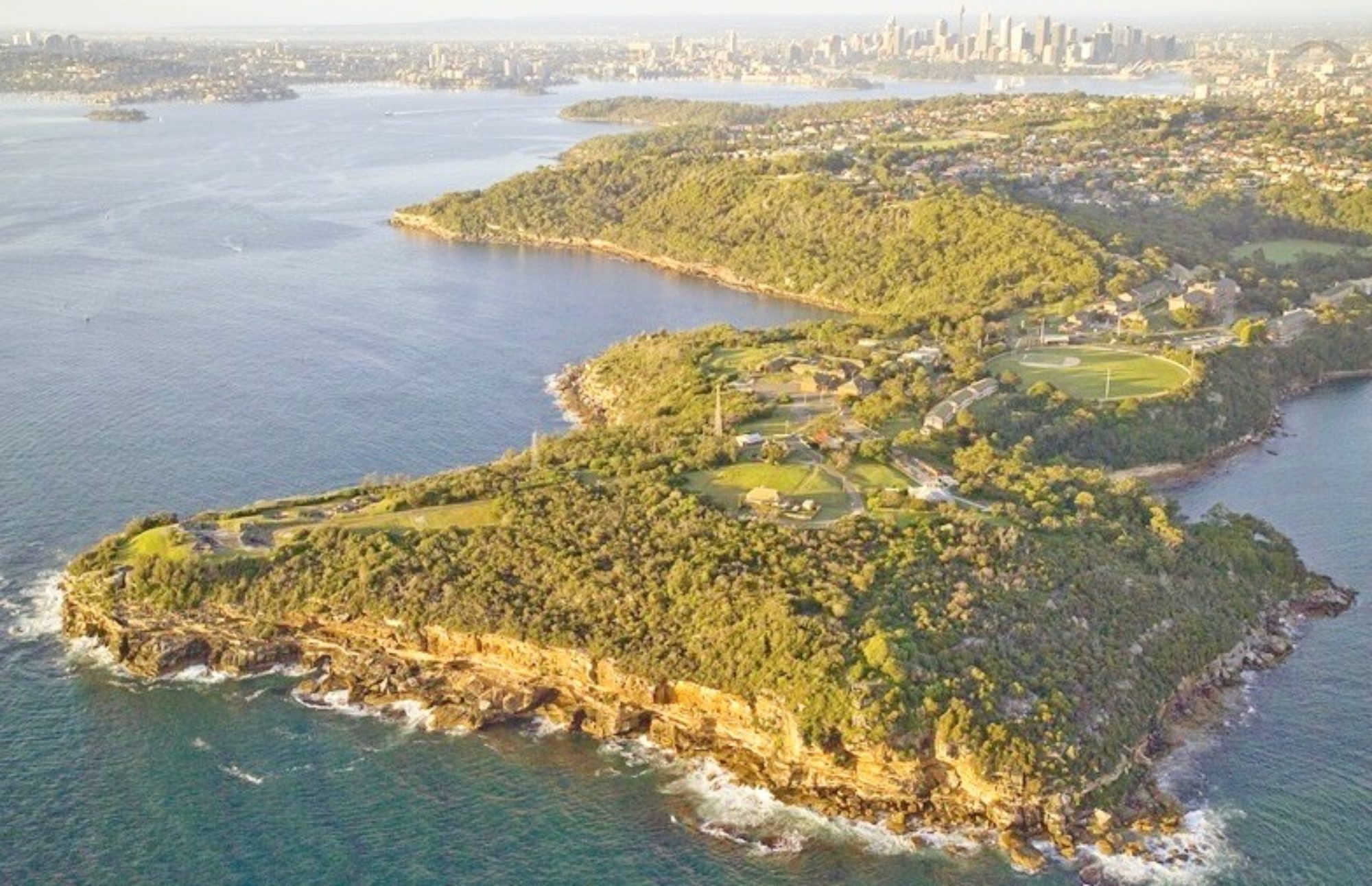
You will notice that Cubba Cubba or Middle Head, to use the English name applied to it during the governorship of Arthur Phillip, is almost dead centre in the area that TRC nominated as the Sydney Harbour National Landscape. As you sail through Sydney Heads and turn to port into the Western Channel you cruise south straight down the eastern side of Middle Head and Georges Head, past Koree (Chowder Bay), then turn to starboard at Booraghee (Bradleys Head) to enter the main, south arm of Sydney Harbour, to finally moor in Warrane (Sydney Cove or Circular Quay).
This is just what the First Europeans on the 1st Convict Fleet nervously did on 26-jan-1788. Middle Head is what those Europeans saw first as they looked ahead in wonderment and probably some fear of what was to become their future home.
It is also highly likely that there were mobs of First Australians observing their arrival from Cubba Cubba (Middle Head), Boree (North Head) and South Head. The men would have been out fishing with spears at the water’s edge, while the women were using lines from very simple bark canoes. We know this because their are archeological records of more than 30 midden heaps of left over fish bones and oyster shells all around Middle Head and the peninsular we now call Mosman.

The well known urban Aboriginal artist, Gordon Syron, has interpreted this scene many times in a number of paintings that can be loosely described as his 11 ships series. Many of the paintings have Cubba Cubba as the viewing point for their arrival. Without being conscious of it Gordon Syron was capturing the view seen by a mob of Cammeraigal people, who considered Cubba Cubba an important part of their country.
Dr Keith Vincent Smith is a well known historian who has studied the history of the Eora People, who lived along the coastal strip of the great south land, centred on Sydney Harbour. His period of interest starts about 1770 when Captain James Cook sailed into Botany Bay and the naturalists and scientists on board, including Joseph Banks and Daniel Solander made very detailed recordings of almost everything they observed of the native flora and fauna of the shallow, sandy exposed bay, just about 15 km down the coast from Sydney Heads. His published works included numerous books and academic papers on Bungaree, who was given a land grant to start a farm on Middle Head by Governor Macquarie in 1815, just before he returned to England at the very end of his positing as Governor of the colony of NSW.
Jeremy Steele is well known for his many years of research on the language spoken by the Eora people. One foundation for his masters degree at Macquarie University, in the 1990s, was the diaries and note books of William Dawes. Dawes was an engineer in the Royal Marines and laid out the first streets in Sydney and Parramatta. But today one of his greatest contributions to Australia was to be the first European to collect and write the language from Aboriginal people.
William Dawes was sent to Tarra or Darra (Dawes Point) to observe a comet that was due in the Southern Hemisphere but was not seen. He had been given instruments for this purpose back in England by Nevil Maskelyne, the Astronomer Royal.
Dawes had plenty of time on his hands while he was stationed up at the southern end of the Sydney Harbour Bridge, with an artillery gun so he could signal down into Sydney Cove the arrival of any ships coming up the harbour. There were very few ship movements for Dawes to signal so he kept himself busy by recording the first written evidence of what language and vocabulary he heard spoken the Eora people who became his close friends on the headland that is still called Dawes Point. One of his most reliable sources was a 15 year old girl called Patyegarang (‘Grey Kangaroo’).
His ongoing research has led Jeremy Steele to hypothesise that the Eora language that William Dawes recorded around the edge of Sydney Harbour, was in fact a dialect of what Steele now labels as the Dharug language. He would have also observed that the Eora language would have had subtle differences too, between what was spoken by the Cameraigals on the north side of the harbour, and the Gadigals on the south side.
In the past 20 years historians and linguists, such as Dr Keith Vincent Smith and Jeremy Steele, have made significant discoveries about the life of the Eora people from the time, through very detailed study of original documents that now reside in museums, galleries andf libraries in Australia, London, St Petersburg Russia and Dublin. We now know with great confidence what the Cameraigals on Cubba Cubba and the Borogegals at Boregegal or Burrogy (Bradleys Head) were doing in their daily lives, what words they were speaking and what was important in their culture, which all ties back to their country and the food they gathered or hunted from it.
The Eora people still refer to themselves as the saltwater people, because this was the source of virtually all their food. Words for fish, canoe, swimming, Middle Head, Bennelong Point, Sydney Harbour, Circular Quay, Dawes Point, Kirribilli and Garden island were all recorded by Dawes, or a couple of other officers or free settlers, who had the free time and writing skills, and were fascinated by the landscape and native people that they were forced to accept as part and parcel of their new home.
Cubba Cubba (Middle Head) deserves to be recognized with an important part to play in both the ancient history of Australia, stretching back at least 30,000 years before 1788, and in the evolution of this first convict settlement into the birth place of a new nation.
It is very appropriate that the Master Plans for Middle Head truly recognise the national importance of this piece of Cameraigal country. Today all that exists to acknowledge this history is a couple of very low profile metal plaques on parts of Middle head that are hardly know to anybody, except the staff of NPWS Middle Head and SHFT staff whose headquarters are located at Georges Heights, plus a few local residents who spend a lot of their recreation time walking and exploring Middle head.
IDEAS FOR CONSIDERATION AT CUBBA CUBBA
1) A MAJOR OUTDOOR SPACE FOR INDIGENOUS THEATRE, DANCE AND CEREMONY
Following informal discussions and input from a wide selection of Indigenous people the Cubba Cubba project team believes this prominent headland deserves a role for Cubba Cubba in the ongoing national dialogue about Recognition and Reconciliation. These two concepts are important parts of the national agenda to confirm the place of First Australians, their culture, history and language as a primary part of a complete Australian story which started more than 30,000 years ago.
A large scale piece of landscape should be created on Cubba Cubba that becomes a focal point for visitors, local and overseas, who want to understand more about the Indigenous history of Sydney. For example, a well defined open space could be established as a venue for Aboriginal dance and theatre performances, for NAIDOC events in June every year, for an outdoor opera performance, starring Deborah Cheetham of course, to celebrate the First People who lived on Cubba Cubba and witnessed arrival of the First Convict Fleet.
Possible uses for this major open air theatre could include
– Welcome to Country events conducted for major international or national conferences held in Sydney
– Indigenous dance events, featuring well known Indigenous dance companies like NAISDA and Bangarra, and the many hundreds of local community Indigenous dance companies from all round Australia and the Torres Strait Islands.
– Nationalisation ceremonies conducted by Mosman Council.
What a magnificent setting! Stage 1 of an open air multi-purpose space like this can be established for a very small amount of initial capital works, as a pilot to see how this piece of landscape should be developed further.
2) FINDING A PLACE FOR THE UNIQUE SCULPTURE BY ANTONY SYMONS CALLED “DANCING WITH STRANGERS”
Antony Symons created “Dancing with Strangers” as a 1/10th scale cast bronze marquette in about 2013, as a competition entry for a memorial to Black ANZACS. Symons’ entry did not win the competition, which resulted in magnificent memorial in Sydney’s Hyde Park. But Middle Head would make a wonderful home for a full scale piece of sculpture based on his marquette, because it is thought that the original historic event probably happened at Cobblers Beach, according to the log entries by John Hunter, captain of Sirius, the Flag Ship of the First Fleet. Alternative sites could be Balmoral Beach further around to the west, or further south of Middle Head at Koree (Chowder Bay). But Cubba Cubba has the dramatic presence to be the home for a full scale “Dancing with Strangers”.
3) RECOGNITION FOR THE GROUP OF FIRST AUSTRALIANS LED BY BUNGAREE
They were settled on Middle Head with a land grant by Governor Lachlan Macquarie in January 1815, during his very successful appointment as the 5th Governor of the colony of NSW, 1810 – 1821.
This group of people were the last survivors of a number of Eora clans and mobs from the Sydney region, after disease has wiped out as much as 90% of the Eora peoples who lived in the immediate vicinity of Sydney Harbour, within 10 years of the First Fleet’s arrival.
Bungaree himself probably came from north of Broken Bay, drawn to Sydney Cove by stories of the many convicts, marines and free settlers who arrived on the 1st and 2nd Convict Fleets. Bungaree appears have to have a natural communicator and found himself a go between the Indigenous people and British arrivals.

Bungaree has recognized by Governor Lachlan Macquarie as a natural leader and selected to be leader of a mob of about 70 people, who came from a variety of clans who lived within Aboriginal walking distance of Middle Head and left isolated after measles and small pox ravished their families and mobs.
There is no definitive written evidence about where Bungaree’s Farm was located on Middle Head. Some evidence points to it being down of the flat where the large car parks are adjacent to the former 10 Terminal Regiment HQ. Other evidence suggests it may be higher up the hill in the area now known as Georges Heights.
Agriculturally the farm was a total failure. But Bungaree’s mob made good use of the rowing boat, nets and other fishing equipment that were given to them. After feeding themselves their excess fishing catch was taken to Sydney Cove where it was eagerly purchased by the starving soldiery, convicts and free settlers.
But the ironic significance of Governor Macquarie giving some country back to a group of First Australians who spoke the Eora language is crying out to be recognised!
What a wonderful anchor of national significance Bungaree’s Farm could become for Recognition and Reconciliation as the national agreements on these 2 topics are debated nationally, by all stakeholders – First Australians and more recent arrivals.
4) HONOURING THE 19TH MILITARY HISTORY OF MIDDLE HEAD
<insert 19th century military history recommendations here>


5) 20TH CENTURY MILITARY HISTORY & HERITAGE
<insert 20th century military history recommendations here>
<A major piece of landscaping dedicated to the concept of “We shall not forget” that recognises all Australians who have served overseas, Caucasian and Indigenous>
<insert some WW I related photos here>
<insert more WW II related photos here>

<insert 2 para about the story of Black Diggers here>

<insert 2 para about the “Tiger Cages” from Vietnam War era>
6) PRESERVING THE EXISTING FLORA
<insert bushland conservation plan here>
7) PROTECTING THE NATIVE FAUNA OF MIDDLE HEAD
<insert fauna protection plan here>
8) WALKING PATHS
<insert map of proposed path network here>
There is an existing network of well used popular routes which deserve to be brought up to a higher standard as funds become available.
Rarely used existing paths probably should be closed off, using new planting of native flora, which is sympathetic to the original native flora on Middle Head.
Primary paths should be brought up to the standard of being wheel-chair accessible. This means elimination of all steps, wide enough for 2 wheel chairs to pass when travelling in opposite directions, and a level surface, which does not have to be concrete, tarmac or stonework. Well designed stabilised earth is perfectly acceptable for wheelchair access providing drainage is well designed and the surface is regularly inspected and maintained.
Secondary paths do not have to be fully wheelchair accessible. For example occasional single steps are acceptable because many wheelchair users are used to negotiating kerbs and gutters on normal streets, sometimes with the assistance of another fully mobile person.
Tertiary paths may be quite narrow and involve significant changes of level, which are defined by existing rocks, low cliffs and very narrow access between two trees. So there is no way that wheelchair users would have access to tertiary paths.
9) SECONDARY OUTDOOR ELEMENTS
Signage
Modern high standard signage is probably the single most important and productive investment that can be made to improve the experience of Cubba Cubba for visitors.
<insert signage proposal here>
Car parking
10) RE-USE OF EXISTING BUILDINGS
SHFT has demonstrated excellent stewardship of the existing building stock within their control, with the notable exception of the former 10 Terminal Regiment HQ complex.
Their conservation and restoration and repurposing of ……… are text book examples of how to new purposes can be found for old buildings.
11) NEW BUILDINGS
No new buildings should be constructed until acceptable re-use has been found for all the existing former military buildings remaining on Middle Head.
12) LANDSCAPING
<insert landscape design criteria here>
<insert landscape design proposal here>
13) SEWERAGE MANAGEMENT
<insert sewerage management criteria and proposal here>
14) TRAFFIC MANAGEMENT
Future uses of Middle Head are severely constrained by the single narrow road, that winds down from Georges Heights.
<insert traffic management and parking proposal here>
15) PUBLIC TRANSPORT
<insert public transport recommendations here>
<include reference to 244 bus route>
<include reference to Mosman Rider>
16) CYCLING PLAN
<insert cycling proposal here>
John Young
21-feb-2017